
Drones + Hosted SCADA = Safe Effective Telemetry Path Analysis
Though modern SCADA systems support a variety of ways to communicate with I/O devices, including Ethernet and cellular, a significant portion of the automation industry still relies on radio hardware. Radios provide a secure and inexpensive way for entities, such as water and wastewater utilities, to securely contact numerous sites that are spread over a wide geographical area. To ensure a robust connection, integrators must perform detailed point-to-point Radio Frequency (RF) analysis of the topography between sites to determine the best location and height of each antenna. This can be strait forward on a flat plain but can be expensive and even dangerous in mountainous, wooded, or swampy areas. For this reason, many companies are forced to overbid or walk away from projects that include these conditions. Below, Devin Carroll, Vice President of Custom Controls Unlimited LLC (CCU), describes their unique solution that combines drones and a cloud-based SCADA application based on VTScada software by Trihedral.
The Best SCADA With Bad Communications is Bad SCADA
“CCU is an industry leader in comprehensive system integration,” says Carroll. “We guide customers in selecting the best control solution to meet their needs. Solutions range from basic upgrades to full-scale state-of-the-art, non-proprietary systems.” Carroll founded CCU in his garage in 1998. Since then, he has spearheaded many of their innovations in control systems integration for agriculture and water/wastewater treatment.
“We do a lot of remote wireless RF-based systems. One of the problems that we faced in our core business was that no matter how sophisticated or how many high-end components we used in our SCADA systems, if they had poor communications, they were practically useless. I’m sure that other SCADA integrators out there have run into this problem. We’ve had some bad experiences where costs got away from us because we were not quite prepared on the front end to know how tall our poles needed to be, for example,” says Carroll.
Computer Modeling
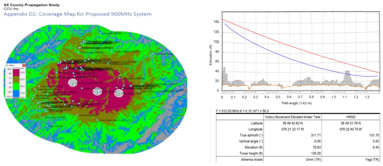
“We would often start with computer models like the ones you see below. The image on the left is called a heat map and it shows how the received signal strength indicators change as you get away from the towers. On the right, you can see how we pick two points to get a cross-section of the earth. The idea is to get that red line to lineup without any obstructions. Despite our best efforts, our computer models were often missing the mark. They were a good start, but it was not getting us there.”
Physical Map Studies
“We ultimately adopted a policy of requiring physical path studies as part of our scope of services when building RF networks,” says Carroll. “There are several traditional approaches and challenges you can go through to do a physical pass study. They involve a lot of equipment, bucket/boom trucks, long cables, and portable towers.”
“It’s a lengthy process. You need to pull out the laptop, connect with the radio interface, either by Wi-Fi access point or long ethernet cable, refresh the interface connection, manually log data, make adjustments, and then manually log the data again. Its very labor intensive and requires a lot of labor force. Plus, not all terrains are flat or easily accessible such as mountain areas. Also, there can often be safety concerns with climbing these towers. This unfortunately creates a roadblock, from a cost perspective, to getting some projects going. We had to come up with a safer, more cost-effective way of doing physical path studies.”
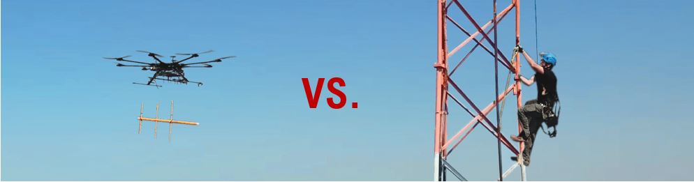
The solution? Send in the Drones
This led Devin and the CCU team to develop a unique strategy to accurately study telemetry paths in areas that are unsafe or uneconomical to do manually. It involved a combination of piloted drones and a built-to-purpose hosted SCADA application.
Components
- Unmanned Aerial Vehicle (UAV) with Dual 4G/900MHz Radio/Cell Modem
- Portable radio tower (when required)
- Hosted Cloud SCADA developed using VTScada software, which continuously polls the drone’s UAV radio for data over private cellular network
- The SCADA system provides real-time data via HMI screens optimized for tablets
“Part of this study may involve putting battery-powered radios on top of existing towers,” explains Carroll. “The radio sits there while we go around to each site to deploy the drone and get our data.” If none are available, a portable tower can be brought in.
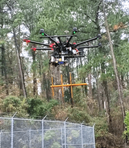
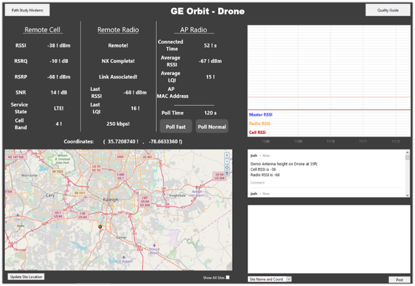
“When we get there, we set up the drone (top right) which has a radio and a 4G cell modem as part of the payload,” says Carroll. “Below that we suspend an antenna that matches the frequency of the private radio network. This transmits to the tower which takes the 4G cell data back into our hosted system which collects the GPS coordinates, the elevations, and the RSSI values and maps it to that location. Then, we’re able to raise the drone up to different elevation check points as we get the feed on our tablets from our hosted SCADA system. We turn to the bearing that we need and that’s how we do it. Below is an optimized screen for the tablet that would display all these values,” says Carroll. “This allows us to store all the notes and the heights and signal strengths. It gives us a live view while we’re doing the test and then saves all this data to ultimately generate the reports we need.”
“Ultimately, the goal is to get to a site, deploy the drone, get up and down in 15 minutes, and get on to the next site. There’s still the human element in it,” Carroll explains. “We have to have a licensed operator that understands all the rules to follow as far as being able to fly a drone commercially.” Depending on local airspace regulations, the drone can access hard to reach terrain at heights up to 400 feet AGL.
A Cloud-Based Solution for Third-party Customers
“Originally, this system was just for CCU. We wanted to know this information before we got into the job and realized we made a mistake on the path analysis. Now, we’ve determined that it’s also valuable to other integrators or consulting firms that want to accurately pre-engineer what all of these heights have to be so they can hire us or someone like us to do the physical path study.”
“We have a hosted SCADA solution for our clients that has a secure private cellular network that tunnels back into our primary and redundant SCADA location sites. Our client SCADA solutions use a variety of communications protocols. Our path study application currently uses SNMP over UDP and we connect to GE’s MIB to get all of that information out of the radio.”
“Even without the drone we can mail a mobile hardware package (for cellular or private radio analysis) out to a customer and we know where it is and what the RF strength values are. We don’t have to deploy people to do it. So, there can be a lot of value to using this method for path studies.”
For more information visit https://www.ccuinc.com.